Environmental Protection

2D Bird & Bat Radar System
SKU: NM1-8A
The Accipiter® NM1-8A Avian Radar System is a software-definable, 2D surveillance radar specially designed to detect and track birds and bats. The system includes one radar sensor integrated into a NEMA-4 rated environmental enclosure, which houses the radar sensor electronics, digital radar processors, radar remote controller, radar data manager, power management and data communications components. The Radar System includes a high-resolution, X-band transceiver with 8’ array antenna that can be operated in either a horizontal or vertical orientation. S-band sensors are also available. The Accipiter® NM1-8A is well suited for use at wind farms for pre-construction assessments and post-construction monitoring, as well as at mining operations to provide bird situational awareness, and to assess and quantify the risk to birds coming in contact with tailings ponds and other hazards that could harm them.
Flexibility and Expandability
Optionally, the Accipiter® NM1-8A can be upgraded to include our patented Deterrent Activation Processor (DAP) which, under smart radar control, can trigger any number of radar-activated deterrent devices deployed to persuade birds and bats to alter their course to avoid possible harm.
The Accipiter® NM1-8A Avian Radar System is built on Accipiter’s patented Radar Intelligence Network™ (RIN) platform technology which allows it to grow to meet your changing needs, flexibly and affordably. Additional sensors can be integrated, including radar sensors to expand coverage, as well as secondary sensors such as ADS-B, AIS, and cameras to increase awareness.

3D Volume Scanning Bird & Bat Radar System
SKU: NM1-24D
The Accipiter® NM1-24D Avian Radar System is a software-programmable, 3D volume surveillance radar specially designed to detect and track birds and bats. The system includes one radar sensor integrated into a NEMA-4 rated environmental enclosure, which houses the radar sensor electronics, digital radar processors, radar remote controller, radar data manager, power management and data communications components. Accipiter’s Total Coverage® 24D agile, X-band dish antenna is user programmable so that it can scan anywhere in the hemisphere. The Accipiter® NM1-24D is well suited for use at wind farms for pre-construction assessments and post-construction monitoring, as well as at mining operations to provide bird situational awareness, and to assess and quantify the risk to birds coming in contact with tailings ponds and other hazards that could harm them.
Flexibility and Expandability
Optionally, the Accipiter® NM1-24D can be upgraded to include our patented Deterrent Activation Processor (DAP) which, under smart radar control, can trigger any number of radar-activated deterrent devices deployed to persuade birds and bats to alter their course to avoid possible harm.
The Accipiter® NM1-24D Avian Radar System is built on Accipiter’s patented Radar Intelligence Network™ (RIN) platform technology which allows it to grow to meet your changing needs, flexibly and affordably. Additional sensors can be integrated, including radar sensors to expand coverage, as well as secondary sensors such as ADS-B, AIS, cameras, weather sensors and FOD detection systems to increase awareness.

3D Bird & Bat Radar System
SKU: NM1-F24D
The Accipiter® NM1-F24D Avian Radar System is a 3D software-programmable, 3D surveillance radar specially designed to detect and track birds and bats. The system includes one radar sensor integrated into a NEMA-4 rated environmental enclosure, which houses the radar sensor electronics, digital radar processors, radar remote controller, radar data manager, power management and data communications components. Accipiter’s manually-adjustable, X-band dish antenna can be set to any angle in elevation to sample birds and bats at altitudes of interest. The Accipiter® NM1-F24D is well suited for use at wind farms for pre-construction assessments and post-construction monitoring, as well as at mining operations to provide bird situational awareness, and to assess and quantify the risk to birds coming in contact with tailings ponds and other hazards that could harm them.
Flexibility and Expandability
Optionally, the Accipiter® NM1-F24D can be upgraded to include our patented Deterrent Activation Processor (DAP) which, under smart radar control, can trigger any number of radar-activated deterrent devices deployed to persuade birds and bats to alter their course to avoid possible harm.
The Accipiter® NM1-F24D Avian Radar System is built on Accipiter’s patented Radar Intelligence Network™ (RIN) platform technology which allows it to grow to meet your changing needs, flexibly and affordably. Additional sensors can be integrated, including radar sensors to expand coverage, as well as secondary sensors such as ADS-B, AIS, cameras, and weather sensors to increase awareness.
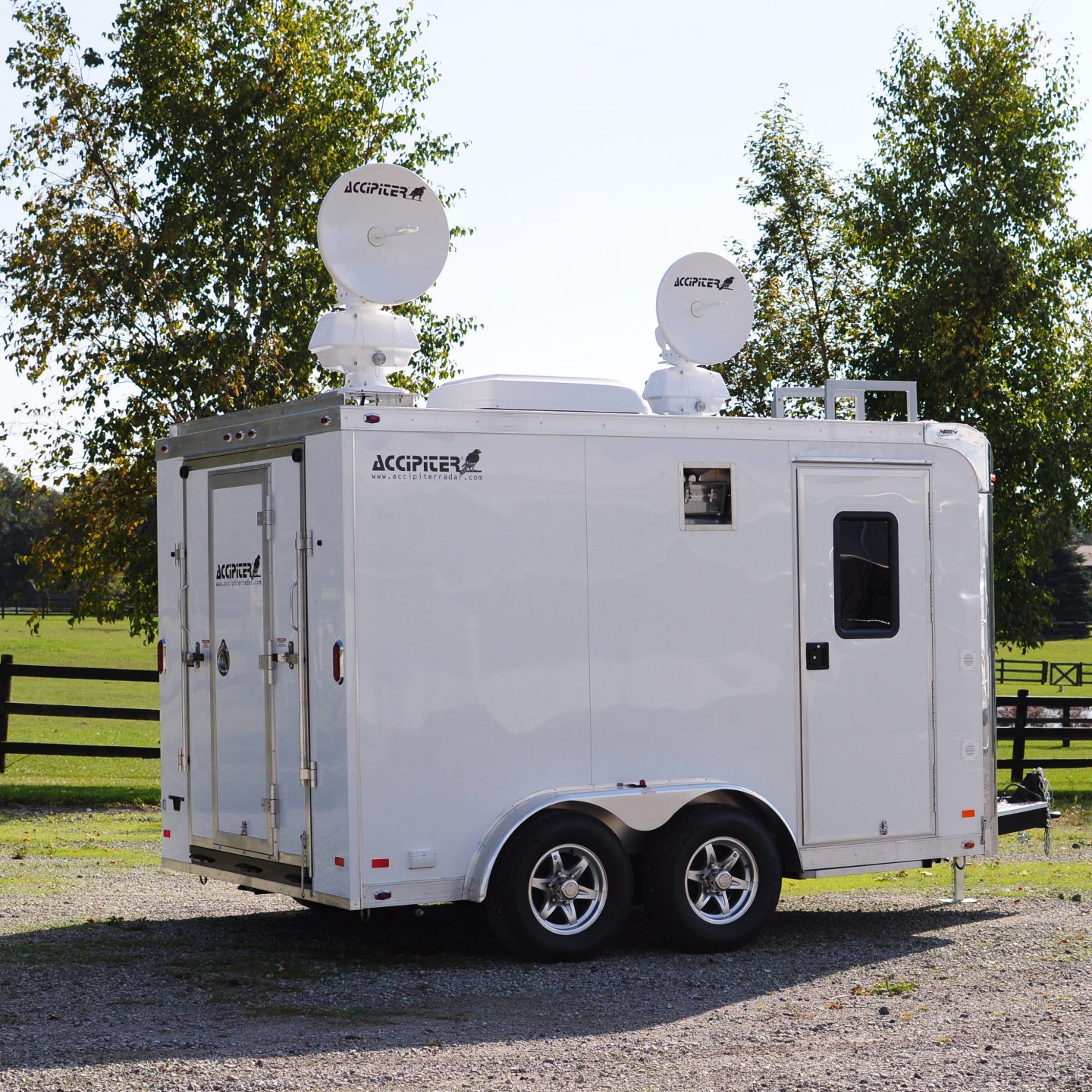
Trailer-Based Dual 3D Bird & Bat Radar System
SKU: TX2-24D/F24D
The Accipiter® TX2-24D/F24D Avian Radar System is a software-programmable, 3D volume surveillance radar specially designed to detect and track birds and bats. The system includes two high-resolution, X-band radar sensors integrated into an environmentally-controlled, relocatable trailer which houses the radar sensor electronics, digital radar processors, radar remote controllers, radar data server, power management and data communications components, as well as providing human work areas. One sensor is configured with Accipiter’s F24D 24” dish antenna that is set to a user-selected, fixed beam elevation angle using a manually-adjustable thumbwheel. The other sensor incorporates Accipiter’s Total Coverage® 24D agile dish antenna that is user programmable so that it can scan anywhere in the hemisphere. The Accipiter® TX2-24D/F24D is well suited for use at wind farms for pre-construction assessments and post-construction monitoring, as well as at mining operations to provide bird situational awareness, and to assess and quantify the risk to birds coming in contact with tailings ponds and other hazards that could harm them.
Flexibility and Expandability
Optionally, the Accipiter® TX2-24D/F24D can be upgraded to include our patented Deterrent Activation Processor (DAP) which, under smart radar control, can trigger any number of radar-activated deterrent devices deployed to persuade birds and bats to alter their course to avoid possible harm.
The Accipiter® TX2-24D/F24D Avian Radar System is built on Accipiter’s patented Radar Intelligence Network™ (RIN) platform technology which allows it to grow to meet your changing needs, flexibly and affordably. Additional sensors can be integrated, including radar sensors to expand coverage, as well as secondary sensors such as ADS-B, AIS, cameras, and weather sensors to increase awareness.